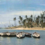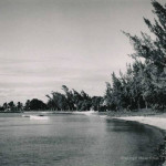
Cap Malheureux – Public Beach – Pirogues – 1960s
Cap Malheureux is a village in Mauritius located in Rivière du Rempart District. The village is administered by the Cap Malheureux Village Council under the aegis of the Rivière du Rempart District Council.
The name “Cap Malheureux” comes from French meaning “Cape of Bad Luck”. It was given by the French who occupied the island then, from 1710 to 1810. The island was often the bone of contention of many great explorers of the time, namely the British. In 1810, the British decided to attack the French to try and take possession of the island. Contrary to French expectations, they did not attack from the island’s harbour in Mahebourg but took the French by surprise by deciding to attack from the North of the island, where the French were weakest in position. As a result, the French were defeated and the name “Cap Malheureux” was named after their defeat by the English who invaded and took over the island from that place.
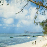
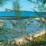
Back in the 1960s, the beach looks somewhat wild, with quite some trees around and those fishermen boats (pirogues) makes this scene idealistic. At the far end we can see the magnificent Gunners Coin island (Coin de Mire) as a fortress watching over the north of the island. Another parallel beach of the same nature is the Bain Boeufs, found not too far from this spot. Image shared by: Keeran Chhaganlall.
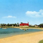
Cap Malheureux is also quite famous and iconic for the scene and the fishermen’s church found in the Village. The church with the red roof, the ‘Notre Dame Auxiliatrice’. It is said that it is the most photographed church in Mauritius. Glimpse below: